I lived in Oregon for about 6 years… Its a beautiful state, and it pays for that beauty with fire and brimstone… unlike its northern neighbor, none of them have breached the surface with it, but most of the volcanoes in the cascades are actively shaking, reminding everyone that it is only a matter of time.
The state is much more volcanically active than its northern neighbor, so much so that despite the fame of the northern volcanoes, Oregon is home to the most volcanoes in any state in the Continental US… Only Alaska has more.
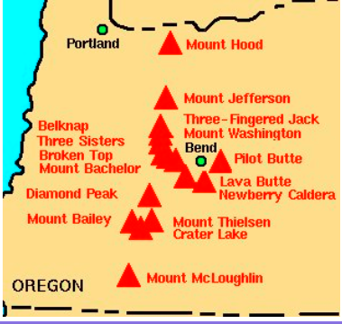
The list is pretty impressive…
Three Sisters | Mt Hood | Crater Lake | Mt Jefferson | Mt Washington | | Three-Fingered Jack | Belknap Shield Volcano | Broken Top | Mt Bachelor | Newberry Caldera | Lava and Pilot Buttes | Diamond Peak | Mount Bailey | Mount Thielsen | Mount McLoughlin
Cascade Region
Volcanism in the Cascades extends from the Garibaldi Volcanic Belt in southern British Columbia to the Lassen volcanic complex in northern California. Pronounced differences in the nature of volcanism occur along the arc. In Washington there are five, generally large, widely spaced stratovolcanoes, with only one ( Mount Adams) having significant nearly basaltic volcanics.
In marked contrast, Oregon has six generally smaller stratovolcanoes, but the entire state is traversed by a 40-50-kilometer-wide band of basaltic to andesitic lava shields, cinder cones, and smaller stratovolcanoes that the “Cascade” cones rise above. South of Crater Lake, the Cascade arc bends perceptibly toward the southeast, and continues along this trend to Lassen Peak. Both Lassen and Shasta are associated with eastward halos of mafic shields and lava fields which, near Shasta, culminate in the huge shield volcano of Medicine Lake.
The Cascade Range has been an active arc for about 36 million years as a result of plate convergence. Volcanic rocks between 55 and 42 million years ago occur in the Cascades, but are probably related to a rather diffuse volcanic episode that created the Challis arc extending southeastward from northern to northwest Wyoming. Convergence between the North American and Juan de Fuca plates continues at about 4 centimeters per year in the direction of North-50-degrees-East, a slowing of 2-3 centimeters per year since 7 million years ago. According to most interpretations, volcanism in the Cascades has been discontinuous in time and space, with the most recent episode of activity beginning about 5 million years ago and resulting in more than 3000 vents.
In Oregon, the young terrane is commonly called the High Cascades and the old terrane the Western Cascades, terms that reflect present physiography and geography. The terms are not useful in Washington, where young vents are scattered across the dominantly middle Miocene and older terrane. …
In Washington and Oregon, a striking contrast has existed for the past 5 million years in the style of volcanism in the Cascades relative to geography. North of Mount Rainier, young volcanism is concentrated in only a few isolated andesitic and dacitic composite cones (notably Glacier Peak, Mount Baker, and the volcanoes of the Garibaldi belt in British Columbia), whereas south of Mount Hood moderate-sized andesitic and dacitic composite cones are relatively unimportant features of a landscape dominated by small andesite and basalt vents. The area between Mounts Rainier and Hood is transitional; large andesite and dacite composite cones ( Rainier, Adams, St. Helens, Hood, and the extinct Goat Rocks volcano) occur together with fields and scattered vents of olivine basalt ( Indian Heaven, Simcoe Mountains, and the King Mountain fissure zone south of Mount Adams. …
The southern Washington Cascades are seismically active. Most earthquakes occur along the 100-kilometer-long, north-northwest trending St. Helens seismic zone, where most focal mechanisms show dextral slip parallel to the trend of the zone and consistent with the direction of plate convergence. Other crustal earthquakes concentrate just west of Mount Rainier and in the Portland (Oregon) area. Few earthquakes occur north of Mount Rainier or south of Mount Hood.
Coast Range
The Coast Range, to the west of the Willamette lowland, consists of several thousand feet of Tertiary marine sandstone, siltstone, shale, and associated volcanic and intrusive rocks.
Willamette Valley
The Willamette Lowland is a structural and erosional lowland between uplifted marine rocks of the Coast Range and volcanic rocks of the Cascade Range. The Willamette Lowland study area encompasses approximately 5,680 square miles, 3,700 square miles of which are underlain by basin-fill deposits.
The Coast Range, to the west of the lowland, consists of several thousand feet of Tertiary marine sandstone, siltstone, shale, and associated volcanic and intrusive rocks. The Cascade Range, to the east of the lowland, consists of volcanic lava flows, ash-flow tuffs, and pyroclastic and epiclastic debris. Continental and marine strata interfinger beneath and adjacent to the Willamette Lowland.
In the northern two-thirds of the lowland, the marine sedimentary rocks and Cascade Range volcanic rocks are overlain by up to a thousand feet of lava of the Columbia River Basalt Group. Folding and faulting during and after incursion of the Columbia River Basalt Group formed four major depositional basins. These basins, separated in most places by uplands capped by the Columbia River Basalt Group, have locally accumulated more than 1,600 feet of fluvial sediment derived from the Cascade and Coast Ranges or transported into the region by the Columbia River. During Pleistocene time, large-volume glacial-outburst floods, which originated in western Montana, periodically flowed down the Columbia River drainage and inundated the Willamette Lowland. These floods deposited up to 250 feet of silt, sand, and gravel in the Portland Basin, and up to 130 feet of silt, known as the Willamette Silt, elsewhere in the Willamette Lowland.
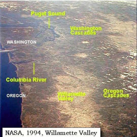
Most of Oregon’s population, technology and agricultural centers, and important transportation, power, and communications lifelines are located in the Willamette Valley of western Oregon. The lowlands of the Willamette Valley extend about 120 km along the Willamette River and contain the major cities of Portland, Salem, Corvallis, and Eugene. The valley is subject to a variety of earthquake hazards (Madin, 1990), and its water and geologic resources are under pressure from rapid urbanization (Gannett and Caldwell, 1998).
The valley is part of the Willamette River drainage basin, which covers 31,715 km 2 between the crest of the Oregon Coast Range on the west and the Cascade Range to the east (Gannett and Caldwell, 1998). The Willamette River is the largest river in the valley and is fed by several major tributaries, including the McKenzie, Calapooia, Santiam, Tualatin, Yamhill and Clackamas Rivers. The valley is the major source of ground and surface water for the population centers.
The valley consists of four sub-basins: the southern and northern Willamette basins, the Tualatin basin, and the Portland basin (see Figure 1). The Waldo Hills separate the southern Willamette basin from the northern basin, and the Chehalem Mountains separate the northern basin from the Tualatin Basin. Northeast of the Tualatin basin, the Tualatin Mountains form the divide with the Portland Basin.
The Willamette Valley lies within a fore-arc basin between the Cascade Volcanic Arc and the Coast Ranges that may have originated in early Tertiary time (Yeats and others, 1996). Some of the sub-basins have accumulated several hundred meters of sediment in late Cenozoic time. The northern basins also contain lavas of the Miocene Columbia River Basalt Group (CRBG). Flows of the CRBG entered the valley approximately 16 million years ago through a low in the Cascade Range and spread into the Portland and northern Willamette basins. The Tualatin Mountains, Chehalem Mountains, Waldo Hills, and Salem Hills are largely composed of CRBG flows that dip inward toward the basin centers (Beeson, and others, 1989, Yeats, and others, 1996). Approximately 3.0 to 0.26 Ma, the Boring Lavas were erupted from several vents throughout the northern Willamette, Portland, and Tualatin basins (Conrey and other, 1996, Madin, 1990, Madin, 1994). Boring Lavas capped the Oregon City plateau (Yeats, and others, 1996) and created many of the prominent small cone-shaped hills and mountains southeast of downtown Portland (Madin, 1990). Between 15,000 and 12,700 years ago catastrophic floods from glacial Lake Missoula inundated the majority of the Willamette Valley (O’Connor and others, 2001). These floods reached up to 120 meters above sea level covering the valley with up to 35 meters of sediment and depositing ice-rafted boulders foreign to the Willamette Valley as far south as Eugene, Oregon
Blue Mountain Region
The Blue Mountains are a complex of mountain ranges and intermontane basins and valleys which extend from the northeast corner of Oregon southwestward into Central Oregon near Prineville. The Blue Mountains are not a cohesive range but a cluster of smaller ranges of varying relief and orientation.
RIGHT: Map showing the Blue Mountain Scenic Byway
The western portion of the province is part of a wide uplifted plateau, while the eastern section contains a striking array of ice sculpted mountain peaks, deep canyons, and broad valleys. In Central Oregon the Ochoco Mountains form the western end of the province. The unique aspect of the Blue Mountains province is that it is a patchwork of massive pieces of the earth’s crust. Permian, Triassic, and Jurassic rocks (300 to 200 million years old) were transported by the Pacific Plate and accreted to the late Mesozoic shoreline, which at that time (about a 100 million years ago) lay across what is today eastern Washington and Idaho. Following the accretion of the terranes there was a vast shallow seaway during covering much of the area during the remainder of the Mesozoic and then slow uplift began. From about 50 to 37 million years ago, eruptions of volcanoes in the western part of the province formed the Clarno Formation. From 37 to 17 million years ago eruptions in the Western Cascades spread ash across the province to form the John Day Formation. From 17 to 14 million years ago major basaltic eruptions covered much of the province with basalt flows to form the Columbia River Group. Continued faulting and uplift has resulted in a deeply eroded landscape. In Central Oregon, at the western end of the province, some deposits of middle Cretaceous age are exposed in the Mitchell area but predominately the area is made up of T ertiary volcanics of the Clarno and John Day Formations and the Columbia River Group.
