With the increased focus on Seattle’s earthquake potential, this seemed a good bit of information to add to my website when I saw this interesting report on USGS…
Lots of folks know that Seattle is prone to earthquakes, but not a lot of people know where the fault lines are in the area…
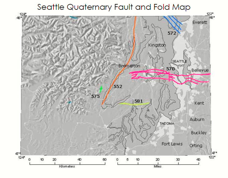
552 – Hood Canal Fault Zone
Counties: Mason, Jefferson, Kitsap
Slip Rate: <.2 mm per year
The northerly striking, Hood Canal fault zone was originally inferred from gravity anomalies and some aeromagnetic data for the Puget Lowlands and the Olympic Mountains directly to the west. Much of the length Hood Canal marks the eastern edge of a prominent gravity high. Interpretation of seismic-reflection data suggests that Quaternary sediments are deformed along a north-northeast-striking zone of faults beneath the northern part of the canal.
The presence of an active fault zone, beneath the southern part of the canal and onland north of the canal, are more speculative and based principally on geophysical anomalies. Interpretation of seismically imaged stratigraphic relations implies considerable deformation of Tertiary bedrock and complex depositional patterns in Quaternary deposits that have been affected by high-angle faulting. In seismic-reflection profiles, these high-angle faults appear to be principally normal faults associated with some reverse faults.
Possible strike-slip offsets along these faults, however, might not be apparent in these profiles, and several regional studies infer from regional relations that this fault zone is principally characterized by right-lateral strike-slip movement. Some interpretations of regional tectonic relations may also suggest that the most recent movement along faults of this zone is as young as late Holocene in age. Inferences of right-lateral strike-slip movement and the possibility of late Holocene movement along this fault zone are based mostly on the apparent westward termination of the Seattle fault zone [570] near Hood Canal. Late Holocene activity along the Seattle fault zone is well documented.
The age, character, and origin of faults that appear to deform Quaternary sediments beneath Hood Canal, however, are not tightly constrained. For example, some apparent faults and faulted relations imaged from seismic data, might instead reflect inherited Tertiary topography enhanced and modified by multiple episodes of Quaternary glacial erosion and glacial and marine deposition. Possible slip rates and recurrence intervals for this fault zone have not been reported. Consequently, at this time this largely inferred fault zone is classified herein as a Class B structure until more detailed studies and characterization of this zone is reported.
570 – Seattle Fault Zone
Counties: King, Kitsap
Slip type: Thrust (dip is South)
Slip Rate: Between .2 and 1 mm/yr
This 4- to 7-km-wide east-trending fault zone extends from the Cascade Range foothills on the east across the Puget Lowland to Hood Canal, crossing Lake Sammamish, Lake Washington, Puget Sound, Bainbridge Island, and the Kitsap Peninsula. Various strands of the fault zone lie largely concealed beneath the major population centers of Seattle, Bellevue, and Bremerton. It forms the northern boundary of a belt of bedrock exposures that cross much of the Puget Lowland.
The depth to bedrock north of the fault zone is as much as 1 km (Yount and others, 1985 #4746; Johnson and others, 1999 #4729). The fault zone has been imaged on seismic-reflection profiles collected in Puget Sound and adjacent waterways (Yount and Gower, 1991 #4744; Johnson and others, 1994 #4730; Pratt and others, 1997 #4737; Johnson and others, 1999 #4729), correlates with large gravity and magnetic anomalies (Danes and nine others, 1965 #4723; Blakely and others, 2002 #4716), and is represented by a prominent velocity anomaly on tomographic models (Brocher and others, 2001 #4718; Calvert and others, 2001 #4722).
These data indicate the zone consists of three or more south-dipping thrust faults that form the structural boundary between the Seattle uplift on the south and the Seattle basin on the north. Blakely and others (2002 #4716) have named three of these structures the “frontal fault,” the “Blakely Harbor fault,” and the “Orchard Point fault.” Nelson and others (2003 #5868) termed the “frontal fault” the “Seattle fault.” The Seattle fault zone also includes north-dipping reverse or thrust faults, such as the Toe Jam Hill fault (Nelson and others, 2000 #4733; 2002 #4736; 2003 #5868), which forms a complex scarp in densely forested terrain on Bainbridge Island.
Slip on both south- and north-dipping faults within the zone probably is associated with offset on a south-dipping “master fault” (e.g., Pratt and others, 1997 #4737) at depth. Surface-deforming earthquakes have occurred on the Seattle fault in the latest Holocene, most recently about 1050-1020 cal yr BP (Bucknam and others, 1992 #602; Atwater, 1999 #4715; Nelson and others, 2000 #4733; 2002 #4736; 2003 #5868; 2003 #6250).
572 – Southern Whidbey Island Fault Zone
Counties: Clallam, Island, Jefferson, Snohomish
Slip Type: Thrust (Dip is SW and NE)
Slip Rate: Between .2 and 1mm per year
This northwest-trending fault zone extends more than 65 km across Possession Sound, southern Whidbey Island, Admiralty Inlet into the eastern Strait of Juan de Fuca. The fault zone is as wide as 5-7 km, correlates with gravity and magnetic anomalies (Finn and others, 1991 #4753; Blakely and others, 1999 #4747), and has been interpreted as a complex zone of transpressional deformation (Johnson and others, 1996 #4751).
575 – Saddle Mountain Faults
County: Mason
Slip Type: Reverse (Dip SE)
Slip Rate: Between .2 and 1mm per year
The Saddle Mountain faults (east and west) are two of four faults described and discussed by Wilson (1975 #5721) and Wilson and others (1979 #5663). In a later report, Wilson (1983 #5822) also discussed possible relationships of these faults and earthquakes in the Puget Sound region. These two northeast-striking faults are present along the southeast flank of the Olympic Mountains and they show evidence for two or more faulting events during the late Quaternary (Wilson, 1975 #5721; Wilson and others, 1979 #5663).
Detailed study of the Saddle Mountain faults, which included trenching and isotopic dating, indicates that latest movement along the Saddle Mountain faults is Holocene in age (Wilson, 1975 #5721; Wilson and others, 1979 #5663). Recently acquired lidar topography suggests that scarps related to the Saddle Mountains faults cut across Holocene alluvium and continue about 10 km southwest of the mapped traces of these faults (Haugerud and others, 2003 #6211).
The northwest-striking Dow Mountain fault intersects the eastern Saddle Mountain fault and shows evidence for late Quaternary offset (Wilson, 1975 #5721; Wilson and others, 1979 #5663). The Dow Mountain fault, however, has a short mapped trace, less than 1 km in length, and is not shown herein for scale reasons. The nearby, inferred Crescent Valley fault of Wilson (1975 #5721) is not shown on the geologic map by Dragovich and others (2002 #5715) and is also not shown or discussed herein.
581 – Tacoma Fault Zone
Counties – Pierce, Mason
Slip Type – Thrust (Dip N)
Slip Rate – Between .2 and 1mm per year
Prominent geophysical anomalies extend west-northwest across the south-central Puget Lowland from the Tacoma region to Hood Canal (Danes and nine others, 1965 #4723; Gower and others, 1985 #4725; Brocher and others, 2001 #4718). Local and regional experts are in agreement that the western, east-trending part of the geophysical anomalies are caused by the Tacoma fault, but no consensus exists for the eastern part.
We anticipate that ongoing investigations will clarify present uncertainties in the location and geometry of the eastern portion and eastern end of the fault. Brocher and others (2001 #4718) and Johnson and others (2004 #6235) suggest that the Tacoma fault is a backthrust to the south-dipping Seattle fault [570], and suggest that structural relief increases westward along the Tacoma fault.
Coastal marsh uplift north of the Tacoma fault at Lynch Cove and Burley (Bucknam and others, 1992 #602), and coastal marsh subsidence south of the Tacoma fault at Wollochet Bay (Sherrod and others, 2002 #6240), are consistent with a minimum of 2-3 m of up-to-the-north slip along the western part of the Tacoma fault about 1,000 yr ago.
Source: USGS – http://earthquake.usgs.gov/regional/qfaults/wa/
